
There's more to the story! View the full interactive map at https://bit.ly/GVP-GIS
In 2021, Grand Valley Power’s System Average Interruption Duration Index (SAIDI) was under 45 minutes. This number is an important statistic that measures the total number of outage minutes per consumer over an entire year. While these results are trending in the right direction, past performance does not guarantee future success. To keep us on the right track, GVP is exploring the capabilities of data mining and mapping technology to help reduce outages in the future.
OPPORTUNITY AWAITS
GVP utilizes an outage management system to track and log power outages on our distribution system. When an outage occurs, it is displayed on a map. Dispatch personnel input data about the outage, such as date, time, duration, cause and equipment affected. There’s only one major problem: When the outage ends, it disappears from the map, and no location information is saved. To combat this software flaw, GVP looked to its geographic information systems (GIS) analyst, Ethan Schaecher, for assistance.
MAPPING CO-OP HISTORY
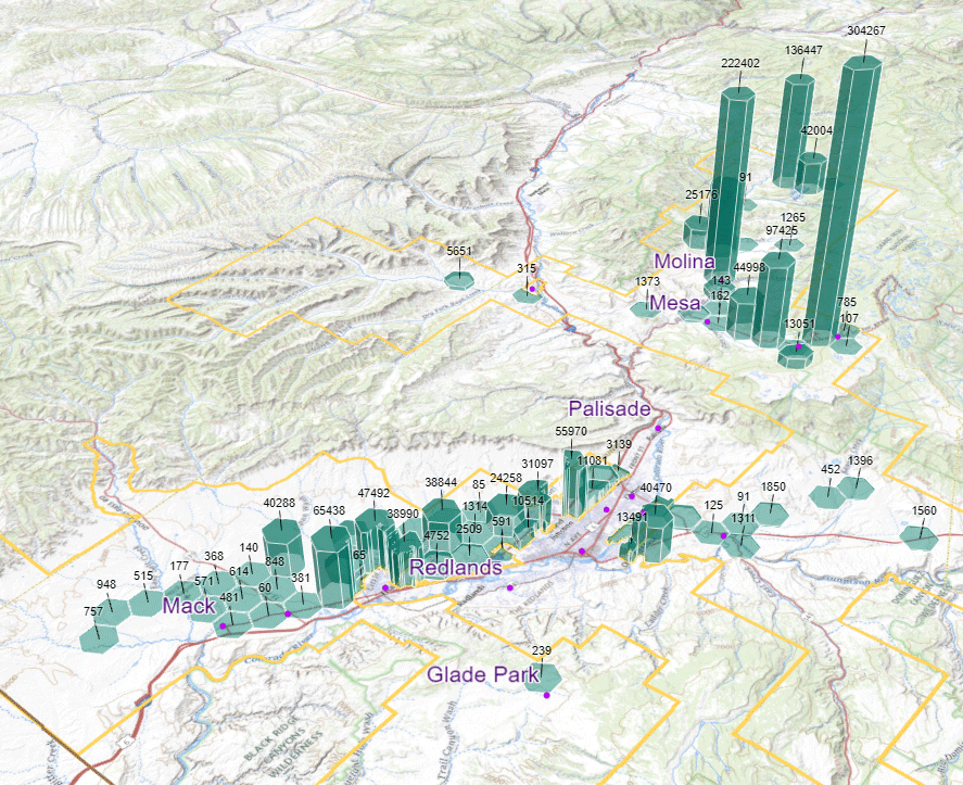
To start, Schaecher analyzed the OMS history records and discovered there was enough data to tie the outages back to GVP’s service map. Then, using data mining techniques, Schaecher could re-plot nearly 2,700 GVP outages spanning from 2012 through 2021. “Beyond mapping the outages as points, I categorized the data into 12 different outage cause types, such as trees. I also had the ability to visualize the outage severity for each cause using hexagons on a 3D map,” Schaecher explained.
Using the graph below, you can see that over the past 10 years, GVP members located on the Grand Mesa have experienced the most tree-related outages. This is unsurprising as the Grand Mesa is home to some of the most unique typography and forestry on the Western Slope. “The 3D map illustrates tree outage severity across GVP’s distribution system. The height of the hexagons depicts the number of minutes customers were out due to tree outages in that area on the map,” Schaecher said. Simply put, the taller the bar graph, the more likely a tree-related outage will occur.
To take this a step further, Schaecher compared the cause of the outage to the time it occurred using a modern graphing technique, better known as a data clock. “Each ring represents a year, and the innermost ring is 2012. The darker the bin, the higher the outage count for that given month of a year. As you can see, tree outages occur most frequently in the summer months, particularly in June,” Schaecher said.

Schaecher applied the methodology to 12 outage causes:
- Trees
- Wildfires
- Bird or Animals
- Public-Caused
- Ice or Snow
- Wind
- Lightning
- Planned
- Power Supply
- Unknown
- Equipment Damage or Failure
- Electrical Overload
You can view them in an online, interactive map at https://bit.ly/GVP-GIS. While you may only see the tip of the iceberg, this GIS technology provides an excellent opportunity for cooperatives nationwide. For decades, maps have been a critical component of GVP’s success for viewing, editing and inspecting data on co-op lines. However, GVP can now visualize patterns in time and space to help solve complex problems and increase reliability to you, our members.